

This is the final post to the In Blume blog. Thank you for following the Blume Library's news on our first blog, In Blume.
Please follow us on Facebook at the library page at http://www.facebook.com/BlumeLibrary. Our Facebook page is a great place to look for information about new services and new books, music, videos, and databases. You can also find out more information about the our library on the Blume Library website at http://lib.stmarytx.edu/home.
Please join us on Facebook, leave a comment, and connect with your library!
Friday, December 6, 2013
Thursday, May 31, 2012
Blume Library expands its JSTOR offerings
Articles from historical issues of more than 190 scholarly journals are included in Arts & Sciences Collection II. Selected journals and publications include African Affairs (1944-1999), American Anthropologist (1888-2004), Brookings Papers on Economic Activity (1970-2011), The Classical Review (1887-2006), The English Historical Review (1886-2001), Hesperia (1932-2008), The Hispanic American Historical Review (1918-1999), The Journal of Hellenic Studies (1880-2008), Journal of Peace Research (1964-2008), Political Theory (1973-2008), and Theory and Society (1974-2008).
Articles from historical issues of more than 220 scholarly journals are included in Arts & Sciences Collection III. Selected journals include American Art Journal (1969-2003), American Speech (1925-1999), Buddhist-Christian Studies (1981-2008), College Composition and Communication (1950-2008), Ethnomusicology (1953-2012), Folklore (1890-2006), The Jewish Quarterly Review (1888-2006), The New England Quarterly (1828-2008), Studies in English Literature, 1500-1900 (1961-2006), South Atlantic Review (1981-2008), and Western Folklore (1947-2006), to name a few.
Explore the JSTOR collections and search or browse our complete journal collections at Locating Journals.
Wednesday, May 2, 2012
It's Election Time!
The Elections & Voting LibGuide has been updated with a link to the generic ballot for the May 12, 2012 election. What's on the ballot? Elections for Alamo Community College District Trustee, Northeast Independent School District Trustees, City Council for Balcones Heights, Castle Hills, Fair Oaks Ranch, Kirby, Leon Valley, Live Oak, Shavano Park, and Hollywood Park. Two of those communities also have a proposition on the ballot. The City of San Antonio has 5 propositions for a bond totaling $596 million and a city charter amendment on the ballot.
Early voting takes place from April 30 - May 8.
 Are you uncertain about whether you are currently registered to vote in Texas or at which address you're registered? Then check out the Voter Information Search database made available through the Texas Secretary of State's office. You can search by Driver's Licence number and date of birth, or First Name/Last Name and date of birth. Try it out!
Early voting takes place from April 30 - May 8.
Are you uncertain about whether you are currently registered to vote in Texas or at which address you're registered? Then check out the Voter Information Search database made available through the Texas Secretary of State's office. You can search by Driver's Licence number and date of birth, or First Name/Last Name and date of birth. Try it out!
Monday, April 2, 2012
No foolin' !

Yes, it's time for the National Archives to release another decennial Census-worth of data on our forebears. This time it's the 1940 Census that will become completely available online, as of 9 A.M. EDT today.
Every 10 years the Census Bureau counts us all, as well as collecting information on where we live, how we work, etc. The aggregated numbers resulting from each Census are available from a few months to a few years after we've filled out our forms.
But the actual forms, with names and addresses, legally cannot be released until 72 years after the Census was taken. This delay protects the privacy of most of the adults counted, and the eventual release is quite a boon to their descendants doing family histories.
At the 1940 Census website you can find a step-by-step guide to finding information in the voluminous files. Plus see an informative video that describes the herculean task the Archives undertook to digitize the previously microfilmed records.
National Public Radio has publicized a bunch of fascinating tidbits from the Census and the year 1940 in general. And they also display this promotional video, made by the Census Bureau to encourage cooperation with the Census takers:
Hint for a real entertaining hoot: take a look towards the end of the video at the "marvelous" punch card machines the Bureau is using to compile all the data!
Monday, March 5, 2012
Women's Education - Women's Empowerment

Women’s History Month is celebrated each year in March with a national theme. The theme this year is “Women’s Education – Women’s Empowerment” which highlights women's struggle for equal access to education and educational programs.
St. Mary’s University is celebrating Women’s History Month by offering a slate of great programs. Program information is available on the university's Women’s History Month site. Most programs are open to everyone.
The Blume Library is also celebrating Women’s History Month with a library book display and related research guide on Women’s History Month. I invite you to stop by the library to check out books on the display and use the Women’s History Month LibGuide to find more books, ebooks, films, databases, and other sources to research women’s history. While you are here, take a look at the current art display (Main, 2nd floor) entitled “Four Women by Women” that shows several wonderful works of art by local women artists.
(Photo: 1915 Vassar College field hockey team. Courtesy Library of Congress in "Female Pioneers In Sports." The Greenwood Encyclopedia of American Regional Cultures: The Mid-Atlantic Region. Santa Barbara: ABC-CLIO, 2004. Credo Reference. Web. 05 March 2012.)
Tuesday, February 7, 2012
Happy Bicentennial Birthday, Charles Dickens!

Today marks the 200th anniversary of the birth of Charles John Huffam Dickens, well-known English novelist and short-story author. Dickens is considered by some to be one of the greatest novelists of the Victorian period.
Some of Dickens' better known works include The Adventures of Oliver Twist, Barnaby Rudge, Bleak House, A Christmas Carol, David Copperfield, Great Expectations, to name just a few.
The Blume Library provides many print and online resources where you can learn more about Charles Dickens and his writings, including Credo Reference, the Gale Virtual Reference Library, and the Literature Resource Center.
Happy Birthday, Mr. Dickens!
"Portrait of Charles Dickens." The Bridgeman History of Science. London: Bridgeman, 2006. Credo Reference. Web. 07 February 2012. Portrait by William Powell Frith located in the Victoria & Albert Museum, London, UK.
Friday, December 2, 2011
What’s going on in the Blume Library?
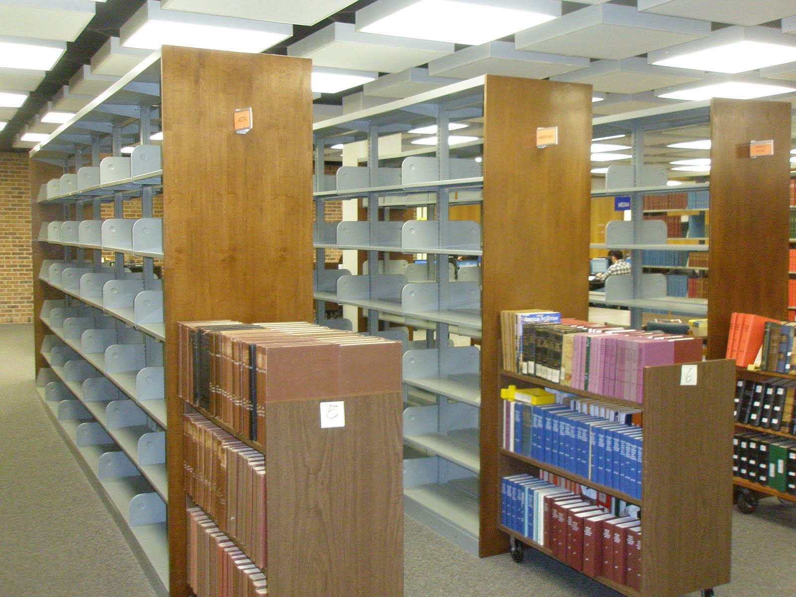
You may have noticed some empty shelves as you walk into the Louis J. Blume Library. We will be starting construction on a new Learning Commons in May 2012 and we are making some preparations for that space.
The library is discarding both journals and reference books that are available to our faculty and students as on-line digital resources. We are NOT discarding non-reference books from the circulating collection on the third floor. This is something we would have done in a leisurely fashion anyway and no one would have noticed. Libraries do it every day, all over the world. If not, we would be buried under tons of useless information and misinformation and the university would have to build a new wing for the library every ten years or even more often. We have had to move quickly this semester because we are starting construction on the new Learning Commons in May and have to move substantial quantities of books and journals between the floors to make the space available.
NOTE: While we ARE recycling material that is useless to our students and faculty, we are not lightly throwing away material that might be useful to other libraries. We are working with Better World Books, a company that redistributes books to libraries serving developing countries and other nonprofits, and sells used books to individuals. We have shipped more than 9 tons of books to them for redistribution or discounted sales to Haiti, various African countries, and other places. We could do no more than that. You can read more about Better World Books in Wikipedia at: http://en.wikipedia.org/wiki/Better_World_Books
 See the environmental metrics document to learn more about this activity, which has brought $8,744.82 back to the library and is being used to purchase ebooks.
Subscribe to:
Posts (Atom)